Press kit
FlightDial
A flight radar that runs on the Apple Watch alone, and turns with your compass.
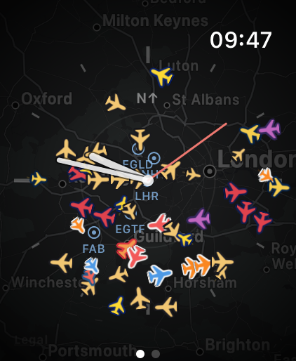
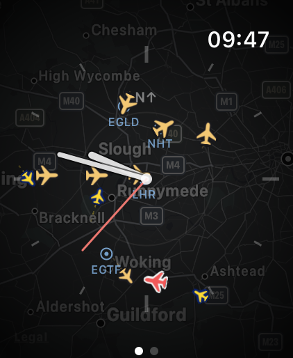
FlightDial is a standalone Apple Watch app that draws live ADS-B aircraft on an analog dial at their true bearing and distance from you. The dial turns with the compass, so a plane at 10 o'clock on the screen is at 10 o'clock in the sky. Look up and it is there. The watch taps your wrist when one is about to pass overhead.
There is no iPhone app, no account and no backend. Aircraft dead-reckon along their track between five-second polls, so they drift smoothly instead of hopping, and everything — dial, terrain map, planes, hands — is drawn in one SwiftUI Canvas. Traffic comes from ADSB.lol community data under the ODbL licence, and the App Store privacy label is Data Not Collected.
Film
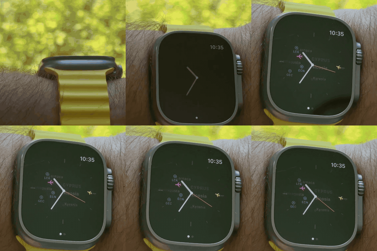
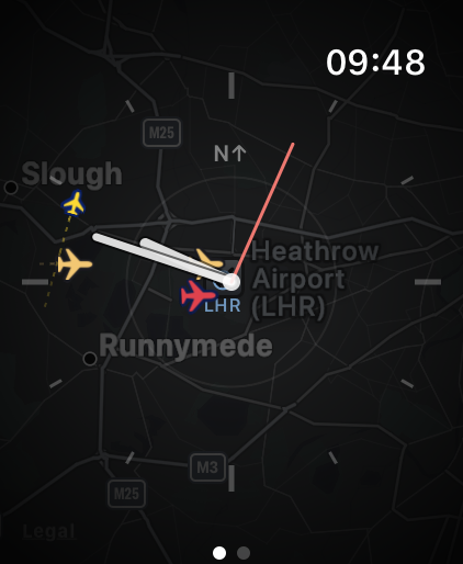
Fifteen seconds on a wrist: the arm turns and the traffic holds its place in the sky, then the crown zooms out until an airport comes into range.
Shot on an Apple Watch Ultra, because the compass and the always-on state do not exist on the simulator. Also supplied as an animated GIF sized to survive an email client.
Screens
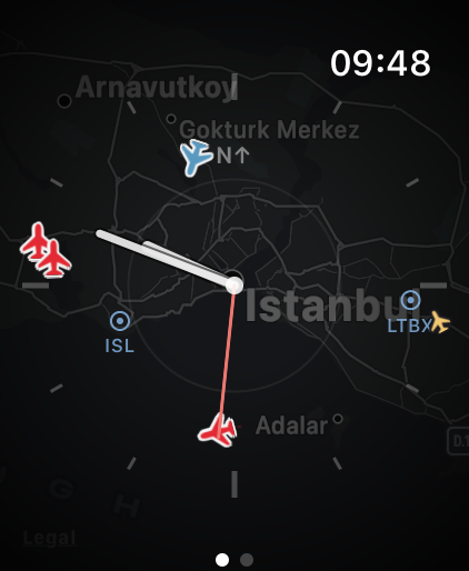
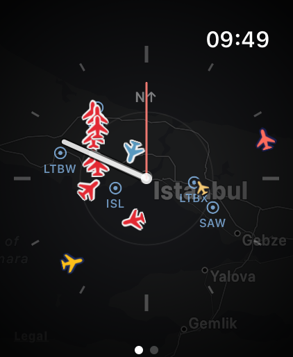
App icon
1024 × 1024 PNG, for article art. Full size, and in the zip above.
Fact sheet
- Name
- FlightDial
- Subtitle
- Live aircraft on a watch dial
- Developer
- Mishigo OÜ, Estonia
- Platform
- watchOS only — standalone, no iPhone counterpart
- Requires
- watchOS 10.0 or later
- Price
- Free. No in-app purchases, no subscription, no adverts
- Released
- 1.0 on 15 August 2026 · 1.0.1 on 16 August 2026
- Category
- Travel · Navigation
- Age rating
- 4+
- Privacy label
- Data Not Collected
- Data source
- ADSB.lol community network, airplanes.live as fallback
- App Store
- apps.apple.com/app/id6798331213
- Press contact
- ali@mishigo.co
What it does
- Live traffic on a clean analog dial, over a terrain map
- The dial rotates with the compass, so screen position matches sky position
- Turn the Digital Crown to zoom from 5 to 30 nautical miles
- Nearby airports marked with their codes, so you can see where traffic is heading
- Tap a plane for its callsign, type, registration, altitude, speed, distance and bearing
- A complication counting the aircraft near you
- A single tap on the wrist when something is about to pass overhead
- Aircraft coloured by operator and sized by altitude
New in 1.0.1
Aircraft are coloured by their operator's livery, so a sky full of traffic can be read at a glance rather than counted.
And when the primary ADS-B source is quiet in a region, the app now falls back to a second network automatically. An empty dial should mean an empty sky, not an empty feed.
How it is built
- One SwiftUI
Canvasdraws the dial, trails, aircraft, hands and captions — no per-aircraft views - A MapKit terrain underlay sits behind it, its camera synced to the app's own projection, so the map can never move an aircraft
- Positions dead-reckon along track and ground speed between five-second polls, capped at 30 seconds of extrapolation
- Trails are stored as geographic coordinates, not screen points, so they survive rotation and zoom
- Polling watches the always-on dimming state, not just scene phase, so the app stops requesting data the moment the screen dims
- 18,000 airports are bundled with the app, because Apple's map data does not know the developer's home airport exists
Data and attribution
Aircraft positions come from ADSB.lol, a volunteer network of ADS-B receivers, with airplanes.live as an automatic fallback. Coverage reflects where those volunteers live: excellent near cities and airports, thin over open water.
Required attribution: ADSB.lol community data, ODbL. This is a licence condition. It appears in the app's settings and in the App Store description, and should accompany any screenshot published from the app.
Boilerplate
FlightDial turns the Apple Watch into a radar screen for the sky overhead. Live ADS-B aircraft are drawn on an analog dial at their true bearing and distance, and the dial turns with the compass, so a plane at 10 o'clock on the screen is at 10 o'clock in the sky. It is a standalone watchOS app — no iPhone, no account, no backend — and it is free. FlightDial is made by Mishigo OÜ, an Estonian software studio.
Using these assets
The screenshots, the film and the app icon may be reproduced in coverage of FlightDial, whole or cropped, without asking. Please keep the ADSB.lol ODbL line with any screenshot.
The app is free, so there is no promo code to request. For anything else — a different city, a specific range, a longer cut of the film, or a question about how it works — write to ali@mishigo.co.